Original Town Map Finds New Home
By John Deming, Atlantic News Staff Writer
Atlantic News, Thursday, December 2, 2004
HAMPTON | If you were told that your salary would be "20 pounds in corne and cattle and butter at price currant," you'd sue too.
This was the response of John Legat, named Hampton's first public school teacher — indeed, New Hampshire's first public school teacher — in 1649. And that is just one quirky historical fact about the town that compelled artist and map-maker Hazle Leavitt.
"It's all the old history you have in the town, and she just sort of encapsulated it," said Gus Knowles, whose wife Diane is a descendent of Leavitt's, and recently donated one of her original maps to the town.
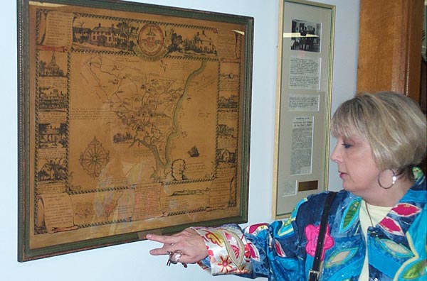
The 66-year-old hand-drawn map — one of four she drew depicting 15th century Hampton — is lined with drawings and descriptions of town landmarks as they stood when Hampton first settled, and has become a part of the town's history itself.
According to Knowles, the selectmen's meeting room had only a replica of Leavitt's map until a few weeks ago.
"Imagine, the town with only a photocopy of the map," Gus Knowles said.
Diane Knowles agreed.
"It really belongs in the town," she said. "It's been behind my bed for 20 years. This way, people can enjoy it."
Town Manager James Barrington said he received a call from Knowles, and he asked her to come in and show him the map.
"Sometimes we get calls like this, and it's just someone trying to clean out their attic or basement," he said. "But this was immediately recognizable as the same thing we had before — just with some enhancements."
Knowles had the map "cleaned up," Barrington said, and placed back in its original frame.
In addition to the skillfully drawn pictures, Leavitt's map pays homage to town legends, including that of Goody Cole, who was convicted of witchcraft — then acquitted — in part of the bygone Victorian era's witch hunt.
"'Fie on the witch!' cried a merry girl/ As they rounded the porch where Goody Cole/ Sat by her door with her wheel atwirl/ A bent and blear-eyed poor old soul," Leavitt wrote on the map, quoting poet John Greenleaf Whittier with impressive calligraphy.
Leavitt drew the maps to celebrate the town's 300th anniversary in 1938, giving one to each of her three siblings, one of whom was Diane Knowles' grandmother.
In the same year, Leavitt won a contest to find a design for the town's official seal. Hampton was the first town in New Hampshire to have a public school, and Leavitt's design depicted the "quaint Hampton Academy building with its picturesque steeple," as written in a 1938 article after Leavitt won the contest.
One reason that Leavitt's seal was chosen, according to the article, was because it "takes cognizance of the fact that the first public school in the state of New Hampshire was established in Hampton."
The seal is hand-drawn at the top-center of the map.
Gus Knowles noted the skill with which Leavitt designed and drew both the map and the town seal.
"To be able to have talent to do something like that — that's a gift," he said. "I'd have been stuck drawing stick figures."
Town history was celebrated with enthusiasm in 1938, the town's tercentennial, and Leavitt's map captures this enthusiasm, noting that Hampton was originally called Winnacunnet — a Native American term meaning "pleasant place of pines" — and was changed to Hampton "in honor of old Southampton, England."
"Things taken for granted look rather quaint and archaic these days," Barrington said. "It's very interesting from our perspective to look back at things that were important in the beginning of the town."
Though she drew three others, the map hanging in the selectmen's meeting room is unique because it may be the first drawn by Leavitt while she experimented with "tinting," according to Diane Knowles. Certain parts of the map — which Leavitt eventually lacquered for safe-keeping — include slight coloration, or tinting.
Leavitt gave the tinted map to her sister Ruth Leavitt [Palmer], and gave the traditional black-and-white maps to her other siblings; all four of them were direct descendents of one of Hampton's founding families, according to the map, which lists the founding families according to year.
The first families arrived in 1638, with the second wave — including the Leavitt family — arriving in 1639.
Barrington said he believes Hampton has a very interesting history, and that the map records it well.
"It's a very nice gift, and we're proud to have it in the selectmen's room," he said.