Forward to next section — Return to Table of Contents
THE SETTLEMENT IN THE WILDERNESS
1638-1646
TOPOGRAPHY
The ancient town of Hampton, New Hampshire, embraced a large territory, lying along the coast between Salisbury, Massachusetts, on the south, and Portsmouth, or the lower Piscataqua settlement on the north; and extending from the Atlantic Ocean westward, about six miles to Squamscott Patent (Stratham) and Exeter, and along the southerly side of the latter town, ten or twelve miles farther; the westerly line running thence southerly to the boundary between Salisbury (now Amesbury) and Haverhill, Massachusetts. The whole area is not less than one hundred square miles.
The surface is somewhat varied, though no portion of it is very rough. In the southeast part, and extending beyond its limits through Salisbury to the Merrimac river, it is very large tract of marsh, or salt meadows containing several thousand acres, as level as any prairie of the West, and, through its whole extent, covered in summer with salt grass. It was this feature of the place, more than any other, that attracted the notice of the government of Massachusetts, and led to its early settlement. The rest of the land near the coast is also remarkably level, but farther back it is more uneven though there are no very high hills. Those of the greatest elevation, east of Kingston old line, are Great, or Hardy’s Hill, and Cock Hill, in Hampton Falls, and Horse Hill, in Kensington.
The largest ponds are Great Pond, in Kingston, covering about 300 acres, and Country Pond, about two-thirds as large, lying partly in the same town and partly in Newton, beyond the original limits of Hampton. The principal rivers are the Winnacunnet, or Hampton river with its tributaries, and Little river, flowing into the ocean; the Winnicut, a tributary of the Piscataqua, flowing into Great Bay, and the ponds named above, which are the chief sources of the Powow river, that empties into the Merrimac between Salisbury and Amesbury.
The coast line of the ancient town was about eight or nine miles in extent, terminating on the north at the easterly side of Jocelyn’s (afterward called Locke’s) Neck, in the present town of Rye. On the coast are two noted headlands, called Great Boar’s Head and Little Boar’s Head. The rest of the coast is mostly a low, sandy beach, some portions of which are greatly admired for their beauty. In several places, the beach is indented by small coves, which being somewhat sheltered from the wind, serve as landing places for boats, and afford facilities for carrying on the shore fishery.
In a territory so extensive, almost every variety of soil was found, In some parts, it was light, sandy and porous, liable to be parched by drought; in others, clayed and wet, or rocky and difficult to cultivate; while, in many places, there was a rich, dark mold of great depth and fertility, yielding to the husbandman an ample reward for his toil. A large portion of the land, except the salt meadows, was covered with forest where grew in great luxuriance the pine and the hemlock; the cedar and the spruce; the beech, the birch and the maple; the ash, the elm, the hickory and the oak. Of some of these there were several varieties. Oaks, both white and red, were extensively used by the early inhabitants in the manufacture of staves, for which a ready market was generally found, the sales bringing in a considerable portion of the money in circulation among them.
The rivers, the brooks, and the neighboring ocean furnished the people with fish; the woods and marshes afforded an abundance of game. Wild animals roamed in the forest, some of which, particularly the wolf and bear, were very troublesome to the inhabitants, and frequently committed depredations upon their sheep and cattle.
A little more than two centuries and a half ago, no part of this tract was inhabited by white men. Some Indians, but how many, we know not, dwelt here. In favorable localities, they built they wigwams and had their homes. The roamed through the forest, and over the marshes, in search of game, which they shot with their arrows. Their trails might have been seen along the banks of the ponds, the brooks, and the rivers, where they often sauntered to draw from them their daily food. On the larger streams, they delighted to paddle their birch canoes. These they held as sacred spots.
After the white men had formed a settlement, there was some friendly intercourse between the two races. The Indian pappooses, it is said, would, in times of peace, often go to the log-huts of the new settlers, to play with their children. But the ancient race soon began to dwindle away, and, in little more than one century, were all gone. Their very names have also perished. Scarcely one is now known, and but very few authentic anecdotes concerning them have been preserved. An arrow-head of flint, occasionally picked up, and in some localities marl mixed with the soil, where they deposited the shells of clams dug for food from the river-flats, are almost the only relics that remain to remind us that this was once the home of the red men.
Their fires are out from hill and shore!
No more for them the wild deer bounds;
The plough is on their hunting grounds;
The pale man’s axe rings through their woods–
The pale man’s sail skims o’er their floods.”
Such was Hampton at any early period. But its ample dimensions soon began to be curtained. The first extensive tract severed from it was the town of Kingston, which soon after removed thither with their families; but as no part of it had been settled at the time of its incorporation, its history will not be given in this work. Next in order was incorporated the Parish of Hampton Falls, including besides the town bearing that name, the present town of Kensington and a considerable part of Seabrook. A few years later, a valuable tract in the northeasterly part of Hampton was annexed to the town of Rye. Soon after, the remaining territory was divided into two portions nearly equal, and one of them set off to form the town of North Hampton.
The present town of Hampton lies on the seacoast, in the easterly part of the county of Rockingham, in latitude 42 degrees 56′ 15″ N. and longitude 70 degrees 50′ 12″ W. (Taken on the site of the Baptist church – U.S. Coast Survey Report). It has for its boundaries, North Hampton on the north; Hampton Falls on the southwest and west; and Exeter on the northwest; while its eastern border, throughout its whole extent, is washed by the Atlantic Ocean. The town is small in extent, having an area of only a little more than 8000 acres. About one-fourth part of it is salt marsh, and sand banks along the coast. The surface is generally level or undulating, nowhere rising into high hills, and consequently the streams of water, none of which are large, furnish but few valuable mill privileges.
Winnacunnet, or Hampton river, is formed by the union of several brooks, or rivulets, some of which, though of moderate size, are usually called rivers. The largest of these are Taylor’s, Brown’s, Falls and Blackwater rivers. One of the brooks early received the name of Nilus, which it still bears. Taylor’s river has its source in a pond in the town of Hampton Falls, and runs southeasterly, forming, for a considerable distance, the boundary between that town and Hampton, retaining its name till it reaches the salt marsh, — and perhaps, formerly to the mouth of Falls river, which flows into it from the town of Hampton Falls, — when it takes the name of Hampton river. Passing on between the two towns nearly a mile farther, it unites with Brown’s river coming in from the northeast, thus forming the main river, which flows on to the ocean, receiving in its course Blackwater river from the south.
The smaller tributaries from the Hampton side are Ass brook, which comes in from Exeter; Great Swamp run, rising in “the old swamp” in the north part of the town; the Mill brook, rising in the central part, — all of which flow into Taylor’s river; and Nilus brook, which has its source in Alder Meadow, near the boundary line between Hampton and North Hampton, and running several miles easterly and southerly, falls into the Meadow pond, and from that passes out southerly into the Spring marsh, where it meets the tide, and soon receives the name of Brown’s river. Dow’s river, more properly called a brook, is a small stream in the easterly part of the town, flowing from Spring Heads into the Meadow pond.
Hampton river is of some value for the purposes of navigation, being of sufficient depth to admit vessels of seventy or eighty tons, though it is somewhat difficult of entrance, in consequence of sand bars, and of sunken rocks that lie off its mouth. It is also productive of other benefits. The main river and some of its branches take a serpentine course through the salt marshes. These and the numerous creeks connected with them, serve both to drain and water the marshes, as the tide ebbs and flows, thus rendering them productive, while they also furnish facilities for taking off the hay in boats.
Along the whole eastern border of the town is a fine, sandy beach, interrupted only by a projecting rocky point near the northern extremity, which shelters from troublesome winds a fishing cove on the southerly side; and about midway, by Great Boar’s Head, which has already been mentioned. This is a singular bluff, lifting itself between two low, sandy beaches, and extending into the sea about one-fourth of a mile, being a triangular shape, and terminating in a point at the southeast. It rises gradually from the salt-marsh and a low ridge of upland on the west, till it attains the height of fifty or sixty-feet above the level of the sea, which at high water washes its base. The eastern half is nearly level at the top, and the whole area is not far from twenty acres.
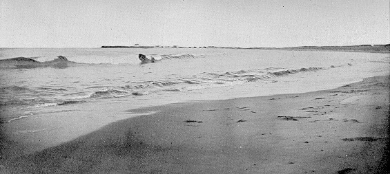
View from the North Beach, Great Boar’s Head in the Distance, Ca. 1890s
From the summit of this bold headland the prospect is varied and extensive, embracing fine views of portions of this, and some of the neighboring towns; of the salt-marsh stretching off to the west and southwest, almost as far as the eye can reach, and beautified by the meanderings of the river; of the blue summit of Agamenticus, far off in Maine; of various points along the coast from Cape Neddock (sic), in Maine to Cape Ann, in Massachusetts; of the Isles of Shoals; and lastly, of the ocean itself, apparently limitless, bearing upon its bosom the white sails of commerce, and with waves, sometimes but gentle undulations, sportively chasing each other landward and laving the shore with a soothing murmur, and sometimes lashed into the wildest commotion by the tempest, rolling in and breaking upon the coast with a deafening roar, that can be heard for leagues.