By D. Fisher — 1900
Back to previous section — Forward to next section — Return to Table of Contents
CHAPTER 5
Along The Road To Hampton
Crossing the river and ascending High street, the road winds away over a spur of Stratham ridge toward Hampton. Along High street are some of the best dwellings in Exeter. Once outside of the village, well-tilled farms are seen on either hand. To the southwest, miles away, are the hills of Kingston. To the south lies a valley some two miles wide bordered by the Kensington hills. Southeast, the view extends over the valley of Taylor’s river toward Hampton Falls. In this wide view are interspersed orchards and meadows, tracts of woodland, and tilled fields, with farm buildings just visible amid their surrounding trees, all combining to form a scene of rural beauty that alone repays the visitor for the journey taken.
Near the eastern border of the township the road descends into the valley of a small stream, known as Ass brook, a small tributary of Taylor river. Why, when, or how so named no one knows. It is enough that it has that name, and is much talked about in consequence.
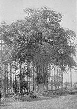
From Ass brook the first rise is known as Dow’s hill. Part way up the rise a highway to North Hampton and Little Boar’s Head branches off on the left. Between the third and fourth houses, on the left, beyond the North Hampton road is a granite post near the highway, which marks the boundary line between Hampton and Exeter. The summit just beyond is known as “Bride Hill.” Popular tradition is to the effect that a hasty and romantic marriage ceremony was performed, early in the history of the town, under the “bridal elm,” a large and peculiar shaped tree to be seen some rods down the slope of the hill on the right. It may be stated that such a marriage did occur under a tree long since passed away, that stood at this point on the left side of the road.
From Bride Hill to the crossing of the Boston & Maine railroad at Hampton station, the road runs south of east for nearly four miles through an ideal section of southern New Hampshire. The surface here is a broad plateau lying between the “great swamp” in North Hampton and Taylor’s river to the south. The road is just below the crest on the south side. The only break in this general level is where the brook which drains the great swamp passes through, just by the power station, to join Taylor’s river.
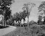
On either hand are typical New England homes. Here are the ample barns, so dear to all children; here are the ever present wells, often with the old well pole and sweep; here are the stone walls, with the “shag bark w’nut” and overhanging apple trees. Almost every one of these farms dates back to the years between 1650 and 1700, and each one has a history. It was on this part of the road, in October, 1675, that Goodman Robinson and son from Exeter were waylaid by three Indians. The elder Robinson was killed, but the son ran into the swamp and escaped to Hampton. This would indicate that the ambush was on the road not far either way from the power station.
Crossing the Boston & Maine railroad, our road turns to the south on the “old post road,” passes Hampton station and the new Odd Fellows hall, and in a few rods brings the visitor to the junction with the line from Amesbury to Hampton Beach. Along the road to the beach lies the greater part of Hampton village.