By Joshua Clark
Hampton Union, Tuesday, March 31, 2009
[The following article is courtesy of the Hampton Union and Seacoast Online]
HAMPTON -- In the era of satellite navigation and GPS, maps have been relegated to a new place, hastily folded into glove boxes and the side compartments of doors. They have become items of nostalgia that pop up during road trips or family vacations.
However, to look back 200 years ago, one would discover maps were works of art used as tools of expansion and promise.
On Saturday, March 28, land surveyor Gerald Miller gave a presentation tilted "Maps of Hampton," which used old maps to show the changes and growth in the Hampton community dating back to the late colonial period.
The first accurate survey of the town of Hampton was done by surveyor Thomas Leavitt and featured on an 1806 map, which included typical scenes on the beach and ships, canoes and small sailboats in the ocean. Fish houses can be seen along the shores along with horse-drawn carriages.
The map contains a profile of each of the houses in town accompanied by the family's name and a make-up of the downtown. A drawing of a windmill is evident as are profiles of each of the town's mills.
An 1892 map of the town, found in an atlas of New Hampshire, provides a stark juxtaposition to the quaint shore-town as drawn almost a century before. At that time, the interior of the town had begun to expand out, with the western part of town building up along Exeter Road. The mills have started to disappear and downtown is almost unrecognizable.
However the most apparent difference between the maps is the disparity in detail. As time went by, Miller said, the artistry and detail on the maps began to decrease.
"The earlier maps have a little more detail and are a little more interesting," said Miller.
Gone are scenes of houses so detailed you can count the number of chimneys.
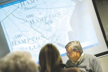 Land surveyor and antiquarian cartologist Gerry Miller, of Hampton, delivers a lecture entitled "Maps of Hampton" at Lane Library on Saturday.
Miller said the majority of maps created during that time were done with a precision and artistry rarely seen today.
"Maps done in the early 18th and 19th centuries were done by people who essentially created works of art," he said.
The maps would contain lettering specific to each surveyor and miniscule, detailed drawings. Included on a number of the maps were drawings of ships in harbors or rivers done with such detail that upon closer inspection you can see flags on each of the ships and people on the decks.
"A lot of these maps were drawn with a single hairbrush to achieve such fine lines," he said.
Miller also pointed out maps that included notes from the surveyor mentioning issues they ran across or stories about specific buildings or landscapes. On some of the maps the drawing is so small a magnifying tool is required to read the text.
He said the maps were not done to create more accurate boundaries, but were essentially "census maps" used to discern who was living in town at the time and where.
Miller spoke of how cartographers and surveyors during the time period faced a number of obstacles and hardships in trying to accurately assess land. They were using, by today's standards, rudimentary tools usually handcrafted by the surveyors themselves, while having to journey on foot across harsh, uneven terrain.
Surveyors were adept at collecting data to describe the interior features of towns such as roads, houses and central buildings.
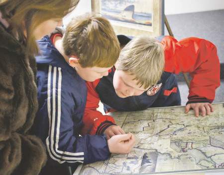
Miller's presentation appealed to residents of all ages as was evidenced by Tina Smith, who was accompanied by her two boys, Adam, 9 and Jacob, 11.
Smith said they attended the event as a result of Adam's intense fascination with maps.
"He was interested in seeing when his street became his street and how the town changed," said Smith.
The presentation was the first in a trio of multimedia exhibits and lectures that will be held by the Hampton Historical Society on the changing character of the town.
Dr. Jere Daniell will present the second program, "The New England Town," which will focus on the behavior of the residents of Hampton. It will be held on Saturday, May 9, at 7 p.m., at the Tuck Museum.
The final presentation will use postcards and other images to show a "then and now" view of the town. Betty Moore and Elizabeth Aykroyd will present on Sunday, June 28, at 2:30 p.m. It will also be held at the Tuck Museum.
HISTORIC EXHIBIT
What: Dr. Jere Daniell's presentation of "The New England Town" will focus on the behavior of Hampton residents.When: Saturday, May 9, 2009 at 7 p.m.
Where: Tuck Museum, 40 Park Avenue