Hampton Union
July 1971
HAMPTON, N.H. — Never has a piece of history led to so much controversy as Bound Rock.
It all started way back in the year 1630, when the King of England mistakenly granted a tract of land to two colonies. The northern boundary of the Massachusetts Bay Colony was decreed to lie three miles north of the Merrimack River, while the southern limits of New Hampshire were specified as the middle of the Merrimack. With the rights of the two neighboring colonies thus overlapping in this tract of land, the controversy first began to brew.
Since both colonies had legitimate claims to the land, they both exercised the right to tax residents in the area. Those who refused to pay taxes to two colonies were confined in prison in Salem, Massachusetts.
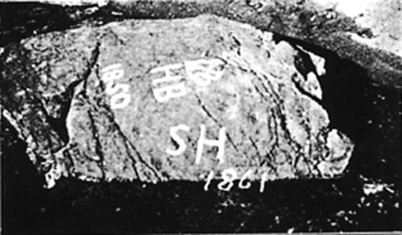
The dispute came to the attention of the Court, which, in 1656, appointed a surveyor to determine a boundary line. He decided upon a ledge in the middle of the Hampton River, which was marked “H.B.” for Hampton Bounds. From that time on, the ledge was referred to as Bound Rock.
The forces of nature set to work on the rock, and within a century covered it with ten feet of sand. The ocean and winds during this span of time also filled in much of the bank of the Hampton River and moved it three hundred rods north. The line between Massachusetts and New Hampshire was then set at three miles north of the Merrimack River again.
At this time, a new town named Seabrook was chartered between Hampton and Salisbury. The state limits had been resolved, but a new dispute about the borderline between the towns of Hampton and Seabrook sprung up.
With Seabrook again claiming the Hampton River as the boundary between itself and Hampton, the case came before the New Hampshire Supreme Court in 1953. The Court found in favor of Hampton, stating that Bound Rock was “a fixed and immovable bound and remains in the same position, whether it be covered with sand as it now is or whether it be in the harbor’s mouth with water on all sides as it was in 1908-1910.”
The land area awarded to Hampton in this decision involves $200,000 of taxable property. But with gains come responsibilities, and Hampton must now provide town services for the people in this area.
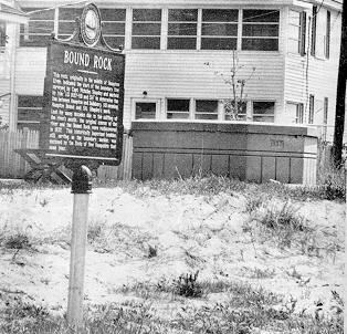
Bound Rock, which has been the center of a blazing controversy for hundreds of years, now rests at the bottom of a protective cement well off Woodstock Street at Seabrook Beach. The lot on which it sits was purchased by the town of Hampton in 1956 at the price of $2,000.
Bound Rock’s fame in the border dispute is now equaled by its distinction as the second oldest boundary marker in the entire country.