- Bound Rock
- From New Hampshire Highways, October 1931, by James Walter Goldthwait.
- The Bound Rock Case
- From Peter Randall’s Hampton: A Century of Town and Beach, 1888-1988
- Who Owns What? Bound Rock Tells All
- A story from the Hampton Union, July 1971.
- Bound Rock Has Interesting Local History
- From The Merchants Review, April 11, 1968.
- Bound Rock Has Interesting Local History
- A story from the Hampton Union, July 1971.
- Who Owns What? Bound Rock Tells All
- From Peter Randall’s Hampton: A Century of Town and Beach, 1888-1988
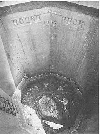
with its protective well in the background
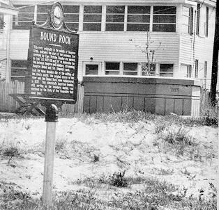
New Hampshire Historical Marker
Bound Rock — No. 120
Designation & date installed: Hampton (120) 1978
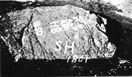
Description: “This rock, originally in the middle of the Hampton River, indicated the start of the boundary line surveyed by Capt. Nicholas Shaply and marked by him “AD 1657-HB and SH” to determine the line between Hampton and Salisbury, HB meaning Hampton Bound and SH, Shaply’s mark. Lost for many decades due to the shifting of the river’s mouth, the original course of the river and the Bound Rock were rediscovered in 1937. This historically important boulder, still serving as the boundary marker, was enclosed by the State of New Hampshire that same year. The marker was erected in cooperation with the Town of Hampton.”
Where is it? To get to Bound Rock, take Route 1-A south toward Seabrook. Take the first left past the bridge over the Hampton Harbor Inlet, which is Eisenhower Street. Following Eisenhower to Campton Street, turn right onto Portsmouth Street, then left onto Woodstock Street.