Back to previous chapter — Forward to next section — Return to Table of Contents
THE BOUNDARY LINES, 1639-1742
Soon after the settlement of Hampton, a controversy arose with Salisbury about the line between the two towns, which was the beginning of a controversy between New Hamphsire and Massachusetts, that vexed the colonies continually and has but recently ended. These towns were granted about the same time, and it was intended that the southerly boundary of the former should be at the distance of three miles north of the Merrimac river, while the latter should embrace all the territory between Hampton and the river. At the same session of the General Court, in which Mr. Bachiler and his company had obtained permission to form a plantation here, measures were taken to run out and establish this line. The court appointed for this purpose Goodman Woodward and Mr. John Stretton, who were to be aided by an Indian, probably a guide, and two other men to be selected by the magistrates of Ipswich.
Not long after, Mr.Bachiler received from the town of Hampton a grant of 300 acres of land for a farm, to be laid out adjoining to the Salisbury line. But from some cause–whether through any fault of the court committee, or of the lot-layers of Hampton, does not appear,–a small portion of this farm lay on the southerly side of what Salisbury claimed as the true boundary of the towns. Perhaps, however, the difficulty arose without any fault on the part of committee or lot-layers. The Merrimac, near its mouth, passes through an extensive bed of sand; and its channel and course are often altered more or less, through the influence of storms and tides. From change thus produced, this protacted controversy about the boundary lines may have arisen. The subject was frequently brought to the notice of the General Court by petitions, sometimes from one of the towns and sometimes from the other. Committees were appointed in several instances, and sent out by the court, to view the line and hear the statements of the parties; but the reports of the different committees were almost as discordant as the views of the people of the two towns.
The first committee, appointed after the settlement of the towns had actually begun, was in 1640, as already related. Both towns seemed to be satisfied with the report of this committee, as they understood it; yet put upon it so different constructions as to furnish matter of dispute for many years. Hampton claimed a straight line from the river’s mouth to the uppermost, or the southwestern corner of Mr. Bachiler’s farm, and Salisbury contended that it ought to run straight to the lower, or southeastern corner, and then the southerly side of the farm to be the line between the towns from end to end of the farm. Concerning the upper part of the line, there was at that time, no controvers1y.
On the 16th of May, 1654, the town of Salisbury petitioned the court, setting forth that the report of the former committee needed explanation, and asking the court to hear their cause, and “so make a full and finall determination as itt shall seem best to their goodly wisdomes.” In October following, the court, in answer to this petition, judged it “requisite that the Towne of Hampton, should have legal notice to answer and make theire claimes and defense before any further proceedings in the case.”
The next spring, May 15, 1655, acting under a general order of the court for all the towns in the colony to lay out the bounds of their respective towns, committees from Hampton and Salisbury met and appointed Mr. Fletcher to act as surveyor, and ascertain the course of the Merrimac, and to lay out the line on the same point of the compass from the most southerly part of Mr. Bachiler’s farm westward to Haverhill, which was the western limit of both Hampton and Salisbury. The course was found to be west, half a point northerly, and the line was run accordingly, to the mutual satisfaction of the parties.[Hampton Records] The lower part of the line was left undetermined.
The next autumn, the court appointed and impowered Mr. William Payne, Mr. Edward Woodman and Mr. Matthew Boyes to settle the difficulty.
April 15, 1656, the line being still in controversy, the people of Hampton resolved to prefer a petition to the next General Court, for relief “aboute the lower part of the line and the farmes of Hampton wch Salisbury lay claim to.” William Fifield was chosen a messenger to Mr. Dudley, to request him to prepare the petition. On the first of May, Fifield was also chosen agent to the General Court, and fully impowered to manage the business in behalf of the town; and to employ such assistance as he and Henry Dow, the town’s deputy, might think proper.[Hampton Records]
The petition, presented at the next session of the court, which began on the 14th of May, was answered by an order, that Mr.Samuel Dudley, with the former committee, or any two of them, should again investigate the subject, make their report to the next General Court and accompany it with a “Plat draune & signed by some Artist.” The expense, in this case, was to be borne by Hampton.[Provincial Papers I:221]
The committee failed to act, or, at least, to make any return of their doings to the court; and in October, 1656, the court “ordered that Capt. Bryan Pendleton, Mr George Gittings, Robt Lord and Ensigne Howlet, or any three of them, shall be a committee to setle all differences betweene the two townes in reference to theire bounds according to the last order of this Generall Court, making Retourne thereof to ye next Court of Elections.”[Mass. Records]
Their return, dated April 7, 1657, states, that having been upon the place and viewed the ground, and heard the allegations on both sides, the committee, acting according to their best skill and understanding , agreed, “that the boundary line should run from the bound tree, standing by ye Rode way in the corner of Mr. Bachiler’s farm, from thence upon a strate Lyne to the middle of Hampton River mouth, only aloweing forty acres of marsh meddow unto the Towne of Salsbery on ye North syde of the sayd Lyne adjoyneing to the sayd Lyne and upland.”
May 6, 1657. The people of Salisbury appear not to have been satisfied, and they again petitioned the General Court for further action. “The Court judged that the bounds referred to in the Petition were ‘not yet perfected & legally settled,’ especially as a former order of the Court, requiring ‘a true platt signed by some Artist‘ had not been complied with, so that the work was ‘not orderly finished, nor the returns fit to be recorded.’ ” For these reasons, the court appointed five commissioners to act in the case, according to former orders of court, their action “to stand firme & good, Provided that Capt. Nicholas Shapleigh of Charles-Towne be procured by the partyes to Asist the comissioners in drawing out a platt and running the lyne according to their direction; the chardge of the Commissioners to be borne equally both Townes–And the Artist to be payd by Salisbury only; and that a true Retourne be made of what is donne herein, to ye next session of this Court to be ratified and confirmed.”[Mass. Records, III:432]
The return of these commissioners, omitting the preamble, is as follows:[Provincial Papers, I:231] “That the bounds betweene the two Townes menconed towards the sea is [are] to be upon a straight line beginning at the middle of Hampton Rivers mouth and Running upwards unto a marked tree and standing at the uppermost corner of the farm commonly called Mr. Bachiler’s farme–the sayd line to Runne upon a west north west point of the compasse nearest, and the said lyne being so Runne by both Townes & marked out according as Capt. Shapleigh hath now draune the platt, wee Agree upon consideration of all pleas, that the Towne of Salisbury shall have and enjoy thirty acres of marsh on the north side of the said line towards Hampton at the lower end of the said line to be layd out by both Townes and Adjoyning to the line; Also for the upper line into the woods, wee determine that the line shall runne from the marked tree before mentioned upon a west and by North line nearest according as Captaine Shapleigh hath given in the line of the treading of Meremacke River, the which wee conclude to be the bounds betweene the said Townes unto theire utmost extent towards Haverill; wee doe further declare that what marsh the Towne of Salisbury hath laid out to any of theire Inhabitants, that shall fall within the lyne above menconed towards Hampton, they shall enjoy and so much more as shall make up the whole thirty acres, to be laid out belowe the proprieties, if there to be found, or els above, Joyning to the line, and this wee giue as our determination in the buisnes to us committed conserning the prmises.
Witnes our hands this 3d day of the five mo: 1657.
| John Appleton | |
| Joseph Medcalf | |
| Wm. Bartholemew | |
| Dan. Pearse” |
“It is ordered that the Retourne of the committee above menconed wch this Court Allows & Approves of shall stand, & be a finall determination of ye case in controversie betweene the two tounes.”
This settled the bounds between Hampton and Salisbury, both towns, it must be remembered, in the jurisdiction of Massachusetts. In 1677, the upper line into the woods” was perambulated by committee of the townes, whose report is as follows:
Bee it known unto all men by these presents that wee hoes names are under written being chosen Commissioners for ye Toun of Salisbury & the Toun of Hampton to run the Line between the two Townes afore said Accordingly we have Run ye Line and agreed that from the Bound tree att ye corner of Mr. Bachellers farme formerly so called the bounds shall run to a tree marked with S: on ye north Side of the way nere the place called the Hawkes nest, so to run to ye Tree mrked att ye west end of the new meadows which is said to be marked by Capt. Shaply, this is agreed upon, upon condition that the Town of hampton, or any of ye Inhabitants of ye Towne shall injoy Eight or ten acres at the place called the hawkes nest, if it be allready granted by ye town of Hampton aforesaid & from the tre marked at ye westerly end of ye new meadows, we have run the Line to a tree marked with S.H. at the southerly side of Shelter hill from thence to a tree marked with H.S. on the North side of Ledg hill, near Powaus River, from thence to a tree marked with H.S. at ye head of powwaus River by ye pond and so it Runs Threw a seder swamp to a marked tree by the side of ye pond & so ye Line Runs over part of ye Pond to a tree marked with S.H. on ye hill in site of the medow, nere the way that goeth from Exeter to haverhill & from thence to a tre marked with H.S. by stonny river and from thence to a tree marked with S.H. on the south side of hurtellberry meddow: from thence to a tre marked with H.S.; on top of a stony hill; which lieth aboute two or three miles to the westward of yt pond which is ye hed of ye pawwaus River; in witness hereof the afore sayd commissioners have Enterchangably set too there hands this twenty ninth day of Ap rill one thousand six hundred sixty and seven.
| Andrew Greele | Henry Roby |
| William Buswell | Nathanell Ware |
| Wymond Bradbury | John Redmond |
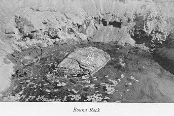
The bound rock may still be found in Hampton river-mouth, marked “A.D. 1657, H.B.” The Bachiler tree stands near the site of the brick school-house, formerly in Seabrook village, on the Newburyport road. The letter “B” is plainly visible on it. All the points are clearly identified to this day.
The same year (1667), the “Haverhill Northwest Line,” so called, between that town and “Salisbury new town” (Amesbury) was established, beginning near Holt’s Rocks, where Rocks bridge now spans the Merrimac, and running a straight northwest course.
Mr. Fred B.French, of South Hampton, to whom we are indebted for many official papers concerning these boundaries, says: “For a long time, the last point, to ‘stony hill’ [mentioned in the return of the commissioners of 1667] was all I found concerning the extent of the Shapley line. But, being in Concord, I examined the charters and plans of old towns, and found the long-looked-for information. The plan of Hampstead, returned in 1749, shows Shapley’s line extending westerly to Angle Pond; also shows the line from Holt’s Rocks, that is, the ‘Haverhill Northwest line’, meeting the Shapley line in Angle Pond.”
This gives us the full extent of Shapley’s line, and shows that both Hampton and Salisbury extended from the Ocean westward, to its intersection with the “Haverhill Northwest line.”
We have seen (Chapter V), that when New Hampshire was declared a royal province, Massachusetts was forbidden to exercise authority over “the towns of Portsmouth, Dover, Exeter and Hampton, and all other lands extending from three miles to the northward of Merrimac river, or any part thereof, unto the province of Maine.”That is, the Shapley line, first established as the boundary between the towns of Hampton and Salisbury, became also, with the promulgation of the new government, in 1680, the boundary between the provinces of New Hampshire and Massachusetts. Thus arose new complications, as during the administration of Lieut.-Gov. Usher.