By D. Fisher — 1900
Back to previous section — Forward to next section — Return to Table of Contents
CHAPTER 10
From Whittier’s To The Beach
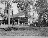
Just across the post road from Whittier’s is the Toppan house, once the house of Col. Christopher Toppan, merchant, shipbuilder, and shipowner, during the storm period of the French and Indian Revolutionary wars. Looking south from the junction, the old house on the left, shaded by great elms, was Col. Toppan’s birthplace. As the cars leave the junction for the beach, on the right is seen a half mile of meadow and tilled fields. This was the “old meeting-house green,” and it is also known in old town records as “the ring swamp.” Directly across this green, to southeast from Whittier’s, stood the old First church of Bachiler’s day, built of logs. The early settlers kept their cows at night in the “meeting-house green.”
The road runs along the northern side of this green. Midway, on the right hand, is the modern successor to the old log church, with a pretty chapel at its side. Just opposite is the town hall and library.
Beyond the church, on the right, is Hampton’s first burial-ground. To look at the old wall with the coping of rotting timber, the worn and rickety gate, the broken, slanting, and often half-buried headstones with time-defaced inscriptions, it is easy to believe that Whittier had it in mind when he wrote,
To death they set apart,
With scanty grace from nature’s hand,
And none from that of Art.
“A winding wall of mossy stone
Frost flung and broken lines,
A lonesome acre, thinly grown
With grass and wandering vines.”
Between the junction and the causeway are many fine colonial houses, each with its interesting history and old-time associations. On the left beyond the town hall may be seen, gently rising toward the north, over a square mile of one of the most beautiful farm scenes in the state. This charming and fertile tract was once the “cow common” of early days. Having passed the last house the road runs upon “the causey” across the narrowest part of the great marsh to the beach, where it turns to the south to Great Boar’s Head.
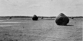
On the right hand, stretching far away to the south and west, lies a salt marsh. This marsh was famous in early local history as “the great ox common.”
As it only needed fencing along the narrower part at what is known as “the causeway,” it was at once selected by the first settlers as the most suitable place on which to pasture their working oxen in common. At their town-meeting in 1641, it was formally set apart for that use “to the world’s end.” No horses or other animals were allowed to pasture there.