The Merchants Review
Thursday, April 11, 1968
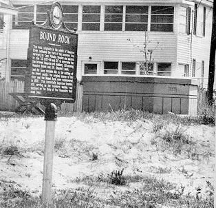
Bound Rock, another Hampton landmark, is the boundary marker between the towns of Seabrook and Hampton. Now situated at the end of and between Plymouth and Woodstock Streets at Seabrook Beach, three centuries ago it stood in the middle of Hampton River.
In the beginning the two towns of Salisbury and Hampton overlapped, and Some Hampton citizens found themselves paying taxes to both towns, to which they protested. This trouble prompted the Court in 1656 to appoint a surveyor to establish the true boundary line. The surveyor, a Mr. Shapley, found a ledge in the middle of Hampton River, which he marked H.B. 1656. He named this rock Bound Rock. In 1768 Governor Benning Wentworth granted a new town called Seabrook between Salisbury and Hampton.
Through the years the tide’s and winds shifted the sands burying the rock and moving the river bank 300 rods, which left the rock where it now stands, on the Seabrook side of the river.
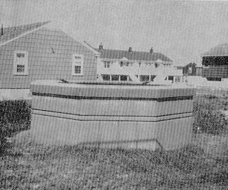
During the present century the Highway Department of New Hampshire erected an octagonal bulwark of cement around the rock to protect and preserve it for posterity.
New Hampshire Historical Marker
Bound Rock — No. 120
Designation & date installed: Hampton (120) 1978
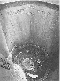
Description: “This rock, originally in the middle of the Hampton River, indicated the start of the boundary line surveyed by Capt. Nicholas Shaply and marked by him “AD 1657-HB and SH” to determine the line between Hampton and Salisbury, HB meaning Hampton Bound and SH, Shaply’s mark. Lost for many decades due to the shifting of the river’s mouth, the original course of the river and the Bound Rock were rediscovered in 1937. This historically important boulder, still serving as the boundary marker, was enclosed by the State of New Hampshire that same year. The marker was erected in cooperation with the Town of Hampton.”
Where is it? To get to Bound Rock, take Route 1-A south toward Seabrook. Take the first left past the bridge over the Hampton Harbor Inlet, which is Eisenhower Street. Following Eisenhower to Campton Street, turn right onto Portsmouth Street, then left onto Woodstock Street.