By James Walter Goldthwait
New Hampshire Highways
Monthly Bulletin — October 1931
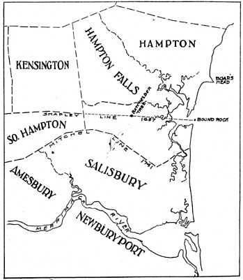
Down on the seacoast, almost in the southeast corner of New Hampshire, is Bound Rock. Although it is one of New England’s oldest landmarks, the rock is little known, for it has usually been out of reach if not actually out of sight. Sometimes swept by the tides of Hampton River or washed by the surf of the Atlantic, and some-times covered by the shifting beach sands of Salisbury or of Hampton, the ledge with its old inscription of “A. D. 1657” has had few visitors during these 275 years.
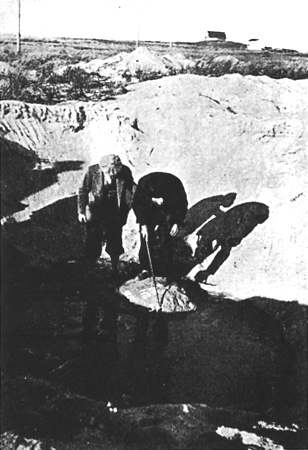
Now, after twenty years burial under Seabrook Beach, it has been brought to light by a crew of experienced diggers, working under the direction of State Highway Engineer William A. Grover, and with the help of accurate records and maps furnished by an old time surveyor and selectman, Fred B. French of South Hampton. Since Capt. Nicholas Shapley’s party cut the date on this ancient Bound, in 1657, governments have come and gone, wars have been fought, and townships have been divided and renamed. Meanwhile, Hampton River and the enclosing beaches have shifted back and forth and in and out amazing distances. But this old rock has stood fixed.
Early documents of the colonies of Massachusetts Bay and New Hampshire, old town records of Hampton, Salisbury and South Hampton and unpublished maps of these old townships made on rare occasions, as well as more modern coast charts and records which Mr. French has carefully and critically reviewed in newspaper articles, tell how and why this boundary was run, and indicate some of the changes of the landscape around it. But the ledge is in such an out-of-the-way place, and it has been tied and untied, buried and revealed so many times, that it has repeatedly eluded selectmen of both towns when they meandered the boundary, and maps have rarely pretended to show its location. The ownership of this part, of the coast was disputed almost as soon as it was settled. Charters issued in 1629 to the Massachusetts Bay colony and to John Mason, original proprietor of the tract that later became New Hampshire, were contradictory. Massachusetts was to extend “three miles northward of Merrimac River or to the north-ward of any and every part thereof”, while Mason’s grants were defined as extending south-ward to the middle of the Merrimac at it mouth, and thence inland sixty miles. Thus, the two domains over-lapped three miles at the seacoast, and much more if the upper part of Merrimac River (then unknown) was to be reckoned with. No survey of the bounds were made.
While Mason’s agents were establishing settlements on the Piscataqua, near Portsmouth, and Massachusetts was settling Newbury and other plantations north of Boston, in 1636, Mason died; and almost at once Massachusetts took steps to assert her possession of the coast. A small “plantation” and a house, long called the “Bound House” were established about three miles north of the Merrimac, on the road from Newbury to Portsmouth, the exact location of which :has long been a disputed question. Two years later Massachusetts granted lands in Salisbury (then called Colchester) north of the river, but within the three mile limit, and lands in Hampton (then Winnacunnet) which lay beyond it.
In May 1640 the Court appointed a committee to set the bounds between her two new towns, Salisbury and Hampton. Their report states:
“wee judge it most equall that the line beginning at Hampton Ryver Mouth running from thence so as to leave Mr. Bachiler’s farme layde out in Hampton bounds…..” etc. etc.
The Reverend Stephen Bachiler (or Bachelder) was one of the earliest settlers of Hampton, an aged man whose active and unconventional life figured conspicuously in the local histories of Lynn, Ipswich, Newbury and Hampton. At the southwest corner of his farm stood a great tree, perhaps visible from the seacoast, though miles in-land. Long known as the “Bachelder tree” it was finally replaced by a flat stone, marked “B T”, which still stands just off the Lafayette Road, beside the Rocks Road in Seabrook village.
The boundary line was probably not marked out in 1640, nor even drawn up on a surveyor’s plan; for Salisbury and Hampton soon commenced disputing its position, Hampton claiming a straight line from the river mouth to the “uppermost” or southwest corner of the Bachelder farm while Salisbury contended that the line ought to run rather to the nearer, southeast corner, and thence along the boundary of the farm to the Bachelder tree. This portion of the line, at least, remained unmarked until 1657.
In 1656, a commission appointed by the court to settle this “lower” portion of the boundary line and to furnish a “Plat draune & signed by some Artist” failed to make return; and again, in April 1657, a commission studied the matter and gave its decision “that the boundary line should run from the bound tree, standing by ye Rode way in the corner of Mr. Bachiler’s farm, from thence upon a streight Lyne to the middle of Hampton River mouth“, allowing forty acres of salt marsh north of the line to Salisbury. As before, Salisbury objected, pointing out that no “Artist” had drawn a plat and the work was “not orderly finished nor the returns fit to be recorded.” So the court once more appointed a commission — this time, five men, to fix and survey the line, their action “to stand firme & good, Prvoided that Capt. Nicholas Shapleigh of Charles-Towne be procured by the partyes to Asist the comissioners in drawing out a platt and runing the lyne according to their direction . . . . . ” So, at last, a Massachusetts Surveyor laid out and marked the boundary between these two Massachusetts towns, Hampton and Salisbury. It has ever since been called the “Shapley line.”
“The bounds betweene the two Townes mencioned towards the sea is to be upon a streight tyne beginning at the middle of Hampton River mouth, and Runing up-wards unto a marked tree, being and standing at the uppermost corner of the farme comonly called Mr. Bachiler’s farme—the said lyne to Runne upon a west north west pointe of the compasse nearest and the said lyne being so Runne by both Townes & marked out according as Capt. Shapleigh bath now draune the platt . . . “
As before, a small portion of salt marsh (30 acres) north of the line, near its east end, went to Salisbury. West-ward the line ran nearly straight to Angle Pond in Hampstead, where it intersected the bounds of Haverhill.
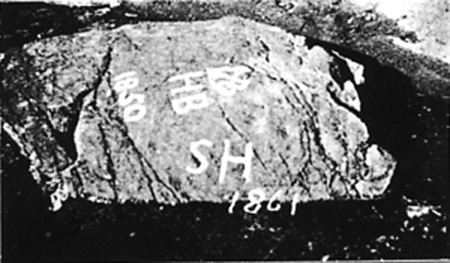
It would be interesting indeed, were it possible, to see the “platt” which surveyor Shapley drew, or to read what memoranda he may have made regarding point’s he located and marked. Among them Bound Rock was probably specified. Anyway, the inscription “A D 1657” leads us to suppose that Bound Rock was visited and marked by Shapley because it lay at or close to “the middle of Hampton River mouth.” As one studies the situation today his curiosity is aroused by the fact that the old surveyors did not mark the highest part of the ledge, but the extreme south end of it, — a small, almost detached portion of it that lies about four feet lower, and within reach of high tide. Measurements recently made put the inscription only 8 feet above mean low water; and the range of tides is 8 1/2 to 13 feet. Has sea level risen, here, during the last 275 years? Geological evidence, though inconculsive, makes it unlikely. Was this southern end of the ledge closest to the Hampton harbor entrance, and perhaps tied to Hampton, north-ward, by a long sandy beach, as other ledges have been tied, in more recent years? The letters “H B” (for Hampton Bound) which stand just below the “A D 1657” and have been considered to be part of the original inscription might imply that that was the case, the rock being on the Hampton side of the line. Maybe sand covered all the ledge except this southern extremity? No other ledge lies near, south of this one, which could have been marked for Salisbury. But opinions differ as to whether the “H B” was cut in 1657 or later, with the date “1850”.
The use of a “B” (for “Bound”) seems superfluous; but that appears to have been the practice in Colonial days. Indeed, Mr. French assures us that boundary stones between towns were often marked in later years by just the one letter “B”! However, when six select-men of Hampton and Salisbury re-ran the “upper” portion of the Shapley line (west of Bachelder Tree) in 1667, according to the Salisbury town records, they marked a number of trees variously “S”, or “S H” or “H S”.
It was not until 1680 that New Hampshire was recognized as a separate province. Then King Charles the 2nd ordered Massachusetts to give up its jurisdiction “over the towns of Portsmouth, Dover, Exeter and Hampton, and all other lands extending from three miles to the northward of the Merrimac River or any part thereof.” So, Hampton parted company with Salisbury. No boundary line was surveyed, on this three mile course, nor was the Shapley line mentioned as answering that requirement. It has repeatedly been said that the Shapley line was once the boundary between New Hampshire and Massachusetts. Mr. French has vigorously denied this claim, more than once, quoting the documents to show that it originated as a boundary between two Massachusetts towns and never became anything else. The point is possibly debatable still; for in Sept. 1701, in an attempt “to prevent contention & controversy that may arise concerning the bound’s of the respective Towns within this Province”, the General Assembly of New Hampshire passed an act “providing that the line between the Province of the Massachusetts Bay and New Hampshire from the sea westwardly shall be the southerly Bounds of the Towns of Hampton“, To be sure, the act did not specify the Shapley line as the “southerly bounds”, nor did it mention Bound Rock. Tradition has had it that there was a rudely carved crown and cross beneath the date “A D 1657” on Bound Rock, somewhat injured by more modern attempts to recut the design in 1850. No sign of such a figure shows today, near the other dates and letters.. It would seem odd, indeed, if this symbol had been used in 1657 to mark a mere Massachusetts town boundary. One is inclined to think that there never was a cross and crown among the markings, or that the “A D 1657”, which is rather crowded into a scrawl, was mistaken for that de-sign. However, more complete exposure of the ledge may some day reveal other inscriptions of other dates, including this
missing one.
With no definite position for the three mile line from Merrimac River, this part of the coast remained a no-man’s land from 1680 until 1741. Taxes were collected by agents from both provinces, who crossed the line and are said to have used fists and canes in personal en-counters. New Hampshire appealed to the king for a solution of boundary troubles in 1734, and received from the solicitor-general and attorney-general a typically helpful (?) decision “that according to the charter of William and Mary, the dividing line ought to be taken from three miles north of the mouth of the Merrimack River where it runs into the Atlantic Ocean”. Commissioners and other dignitaries who assembled at Hampton Falls, with much ceremony, in 1737, failed to establish the boundary, here, and again it came before the king in council. This time the statement was explicit. The line should be “a similar curve line Pursuing the course of the Merrimac River, at three miles distance, on the north side thereof, beginning at the Atlantic Ocean . . . ” and ending opposite Pawtucket Falls (Low-ell) whence it ran straight westward. This crooked line was finally surveyed, accurately and almost as it now stands, by George Mitchel of Portsmouth, in February 1741. It is called Mitchel’s line”. The eastern end of it lies about one mile south of Bound Rock and the Shapley line, being best marked by a ledge called Major’s Rock” back of Salisbury Beach. Mitchell found this “large rock” to lie 3 miles and 220 rods north of the Merrimac. Once Mitchell’s line had been surveyed, in 1742, the irregular strip between the Shapley and Mitchel lines was chartered as a new township, South Hampton. Subsequently (1768) Seabrook was taken out of it. Hampton seems never to have claimed this area south of the Shapley line, though it would have been easy to do so, especially after the Act of 1701. According to Dow, the historian of Hampton, that Act, in which New Hampshire placed her own southern boundary on the
southern line of the town of Hampton was disallowed by the king because it did not recognize the claims of Mason’s heirs.
He is 92, and the inscription
is just three times as old.
An agreement between the towns of South Hampton and Seabrook regarding taxation of non-resident property along their borders in 1795, gives bounds which finish by running along Shapley’s line “eastwardly assaid Shapley’s line runs to the bound rock so called. at Hampton River’s month.” This seems to be the only specific reference to the rock in public documents.
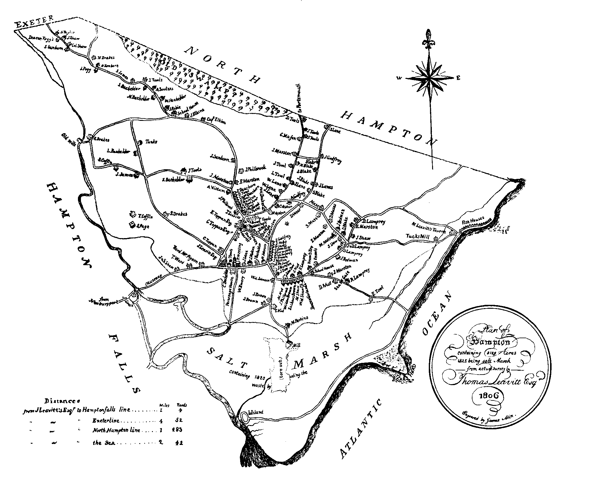
A study of all maps that might indicate Bound Rock and related details of the coastline brings little but disappointment. The oldest that has come to light is an undated manuscript map of “Hampton and North Hill” among the faded documents in a volume entitled “Boundaries” on file in the New Hampshire Historical Society’s library. It was probably drawn before 1742, when North Hill became North Hampton. On it a line from Hampton meeting-house to the southeast corner of the town bears the words “to the Ceders so called, which is three trees standing on sand hills near the River mouth.” Bound Rock does not show. Was it lost? Was it not regarded as the real corner bound ? or were the trees located simply because they were more easily sighted? Samuel Holland’s map of New Hampshire, surveyed in 1772-4, does not show Bound Rock, but does show “Round Rock”, a ledge that lies somewhat farther south and offshore. The detailed Plan of the town of Hampton by Thomas Leavitt, made in 1806, by order of the legislature, indicates the eastern end of the Shapley line as “S 12 W. The Distance Is not known being Bounded on Seabrook on sand & water the boundaries lost & the place is not known”. But the Plan of Seabrook by the same surveyor, in the same year, shows “B. Rock” at the east end of the southern boundary. The Plan of South Hampton, probably of the same date, the ‘surveyor not named, bears the following explanatory note: “The bounds between Hampton and South Hampton, was formerly a marked rock in the middle of the river but now the river is to the north I believe nearly 100 rods.” Carrigain’s map of the State, based upon the foregoing plans, does not show Bound Rock. The Coast Charts of 1855 indicates a little projection on the rear of Seabrook Beach, where Bound Rock should be, but does not name it. The map of Rockingham County by Walling, about 1860, plainly shows Bound Rock by name, with a square black spot, at the north
end of Seabrook Beach, and ‘south of the river entrance. Seabrook, Hampton Falls and Hampton are all shown coming to a corner at this point. It is significant that the rock bears an inscription “S H 1861” near the older ones, showing that it had been found and was again in use 200 years after the original date was carved. Hitchcock’s state map of 1878 shows the rock much as the earlier County map ‘showed it. The old Newburyport Quadrangle of the U. S. Geological Survey (1884-8) puts the rock in the middle of the river, but is not altogether reliable in such details.’
Changes in outline of beaches and river during the last 20 or 30 years, as charted by Coast Survey and N. H. Highway Department, are fully as great as those Of previous centuries.
So, in October A. D., 1931, Bound Rock has been dug out again, and is ready to serve if needed as a bound between Hampton and Seabrook, or merely to stand as a landmark of Colonial days, of uncertain accuracy and significance. Will the two towns, now both in New Hampshire, join hands and adopt the rock as their only fixed corner bound? Will New Hampshire, claiming all coastal lands within range of the tides, seek to establish public ownership of the sands which have wrapped around the rock and covered it since 1912? Terns circling low over their sandy nests in the dune grass, waves pounding and smoothing the face of the beach, and silent grassy marshlands stretching far inland to the villages of Seabrook and Hampton surround this, marked spot with an atmosphere of mystery. Man, while the centuries pass, may come and go across the stage; but nature draws the curtain and shifts the scenes.