By John M. Holman
Contributing Writer
FISH HOUSE AREA (known as “Stimson Seaside Park”) is located on Ocean Boulevard (Route 1A) next to Bicentennial Park at North Beach. This was the site of the early fish houses of Hampton men who went to sea to earn their living. Just one of the original houses remain and has been restored. The “STIMSON SEASIDE PARK” is open to the general public without charge.
MEETING HOUSE GREEN is at 40 Park Avenue, off Winnacunnet Road. The Green is adjacent to the Tuck Memorial Museum which houses artifacts and memorabilia from Hampton’s historic past. On Meeting House Green, the first settlers built their first meeting house in 1638. Here, the first homes were built as early Hampton (then “Winnacunnet” until 1639) grew. The Green also contains buildings belonging to the Hampton Historical Society: the Tuck Memorial Museum, the Fire Museum, the Farm Museum and the one-room district schoolhouse.
NORSEMAN’S ROCK was originally located off Thorvald Avenue in the area known as Surfside Park off Winnacunnet Road. The rock has since been moved to the Meeting House Green at 40 Park Avenue. The rock is thought to mark the burial site of Leif Erickson’s brother, Thorvald, who was killed by Native Americans in 1008 A. D. The legends of local Indians and Viking mythology support this belief. Markings thought to be of Viking origin can be seen on the rock.
DEACON TUCK-LEAVITT GRIST MILL is located at the easterly end of High Street and is now owned by the Town of Hampton and was again renovated in 1985. It is not now in use. From Dow’s History of Hampton, 1892, Page 542, Volume I: “Early in the present century, Tuck’s gristmill had come into the possession of Reuben Lamprey, who sold it to Moses Leavitt. In 1815, Mr. Leavitt took down the old mill, which had become dilapidated, and built a new one, which he and his sons operated. Subsequently, Mr. Leavitt gave the mill to his eldest son, Jonathan, whose widow controlled it till her death, in 1885.”
THE LANDING and LANDING ROAD. On October 14, 1638, Rev. Stephen Bachiler and his small group of pioneers, came up the Hampton River to the Landing and proceeded to the Meeting House Green. They travelled what is now known as Landing Road. The marshland area was the location of the first brickyard, boat-building site and salt works in the early Hampton days. The Landing is located at the end of Landing Road, next to the Hampton Boat Club. Route 101 to the beach now dissects the original Landing Road.
HAMPTON SALT MARSHES are the only natural areas which have been kept exactly as they were when settlers first saw them. They are now wildlife preserves. In former days, the marshes were hayfields for the Hampton community. Sites of the old haystacks can still be seen at low tide. These wooden posts which supported the stacks are called “staddles”. GENERAL MOULTON HOUSE was built in 1769 at 212 Lafayette Road on US Route #1. The area was known as “Haunted House Curve” in the early days. The house was home of General Jonathan Moulton, an active patriot and soldier in the Revolutionary War. Moultonboro, New Hampshire is named after the General. The house is now a private residence.
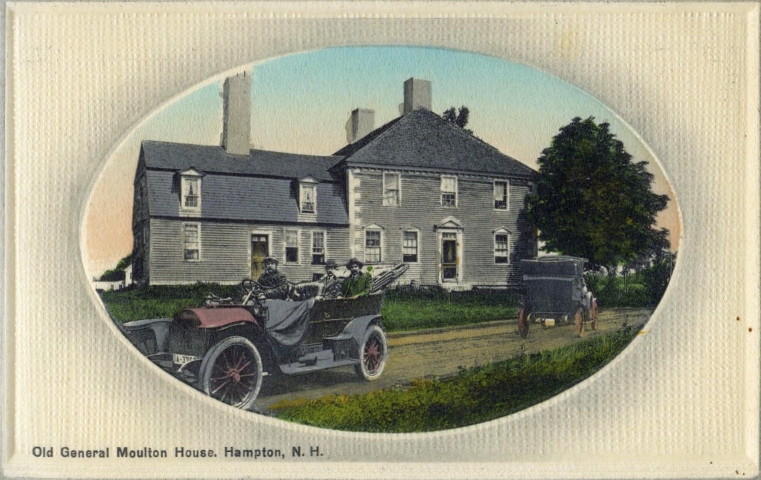
General Jonathan Moulton House
GODFREY DEARBORN HOUSE was built soon after the settlement of the town at 73 Exeter Road. The original part of the house was built in 1648 for Godfrey Dearborn and is believed to be one of the first frame dwellings in the Colony of New Hampshire. It is now a private residence.
FIRST CONGREGATIONAL CHURCH, on Winnacunnet Road, was founded in 1638 by the first settlers. The present church building was built in 1844 and is the sixth meeting house. The pulpit was in the church building when it was built in 1796. The congregation is the oldest, continuous fellowship in North America.
THE FIRST PUBLIC SCHOOL in the state, supported by taxes, was opened in Hampton on May 31, 1649. A New Hampshire commemorative plaque #28 can be seen in front of the Centre Elementary School on Winnacunnet Road and it states:
WAS OPENED IN HAMPTON ON MAY 31, 1649. IT WAS PRESIDED
OVER BY JOHN LEGAT FOR THE EDUCATION OF BOTH SEXES.
THE SOLE QUALIFICATION FOR ADMISSION OF THE PUPILS
WAS THAT THEY BE ‘CAPABLE OF LEARNING’.”
BOUND ROCK was in the middle of Hampton River originally. It showed the boundary line surveyed by Captain Nicholas Shapley and marked by him, “AD 1657 – HB and SH” to determine the line between Hampton and Salisbury. (The HB means Hampton Bound and the SH was Shapley’s mark.) Because of the shifting of the river, the bound rock was lost for many years. It was rediscovered in 1937 and was enclosed by the state in that year. It stills serves as the boundary marker between Hampton and Seabrook.
IRELAND was the name given to the section of town where Philip Towle, progenitor of all of the Towle families of Hampton, originally settled in the 1600’s. Dow states that Philip Towle “is said to have been of Irish extraction; and the locality in Hampton largely owned and settled by his posterity, was on that account, early called Ireland, a name it still (1892) retains.” His Towle descendants can be found on 1841 and 1892 maps living along the east side of Route One/Lafayette Road, between Watson’s Lane and the border with North Hampton.