An Eagle Scout Project by Peter Argue, Troop 177
Presented to the Hampton Heritage Commission, September 2003
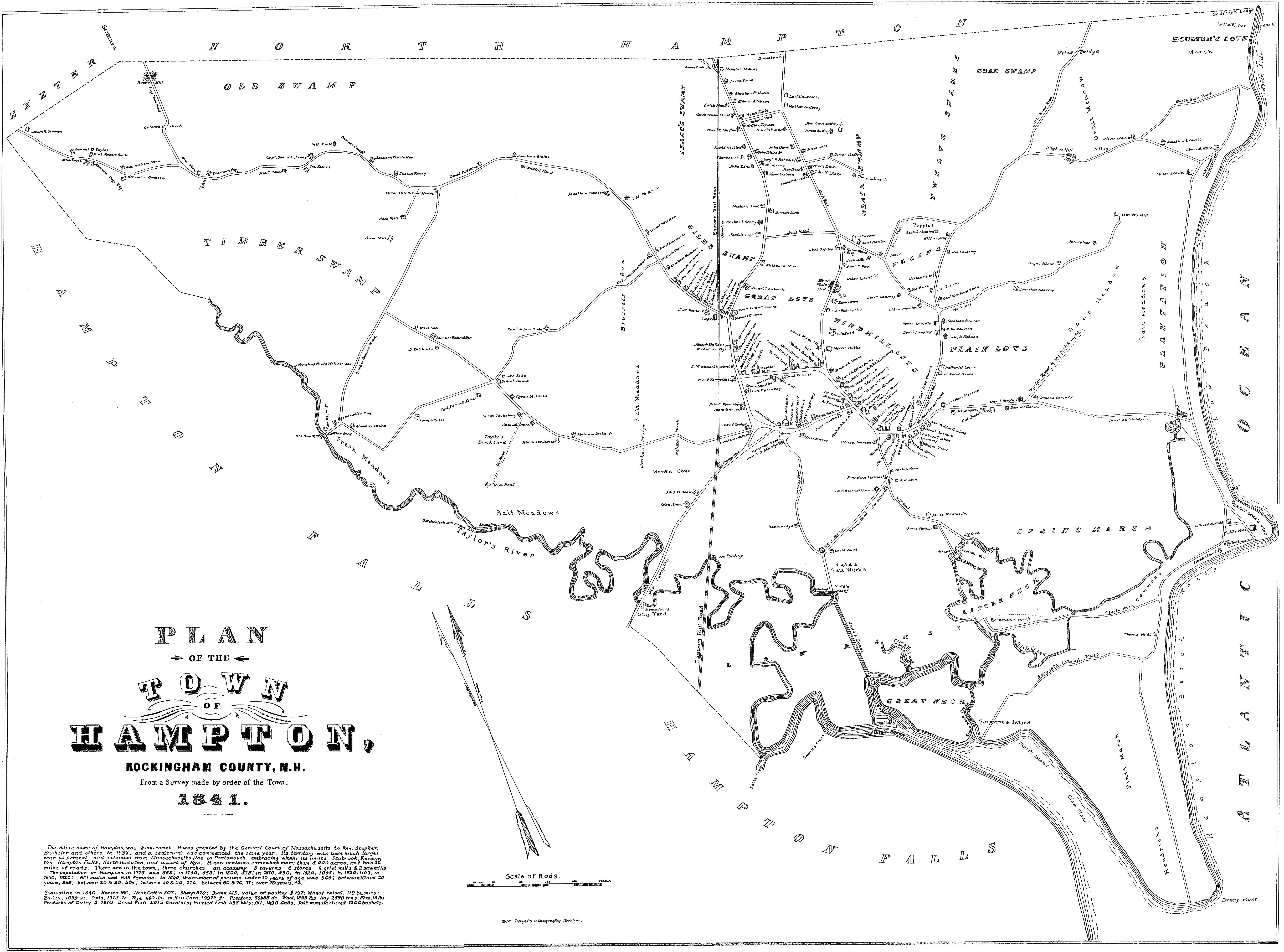
This project was put together by Hampton Eagle Scout Peter Argue with the help of other scouts and local historians. In 1841 a map of Hampton showing every building in town and their owner was produced, and this project was designed to offer photos and historical information on all mapped buildings that are still in existence today. You can see images of this map below:
- 1841 map of Hampton. Below are printable versions in four sections. There is some overlap.
- Western section of town
- Central and western sections of town
- Central section of town
- Eastern section of town and Hampton Beach
All the files listed below are PDF files that require the use of the Adobe Acrobat Reader. House numbers are included for each street.
- Introduction
- Barbour Road
- 63, 77
- Depot Square
- 28
- Drakeside Road
- 200, 263
- Exeter Road
- 22, 33, 45, 57, 73, 93, 129, 389, 411, 459, 466, 563, 569, 660, 663, 743
- High Street
- 20, 318, Old Grist Mill
- Hilda Drive
- 15 (aka 226 Landing Road)
- Lafayette Road
- 160, 212, 234, 400, 413, 490, 495, 699, 724, 838, 852, 868, 871
- Landing Road
- 245, 332
- Little River Road
- 54, 62, 179
- Locke Road
- 24, 61, 85, 93, 98, 101, 107
- Mace Road
- 36, 46, 59, 87, 100
- Mill Road
- 27, 32, 75, 85, 125, 138, 139, 204, 210, 211, 218, 227, 242, 318
- North Shore Road
- 24, 80
- Ocean Boulevard
- 522, 935, Fish Houses
- Old Stage Road
- 3, 11
- Park Avenue
- 47, 60, 86, 87
- Springhead Lane
- 2 (Moved from 346 High Street)
- Tide Mill Road
- 1, 54, 65
- Timber Swamp Road
- 151
- Towle Farm Road
- 186
- Wayside Farm Lane
- 1
- Winnacunnet Road
- 36, 117, 158, 188, 192, 200, 205, 206, 214, 222, 226, 232, 236, 244, 252, 263, 264, 272, 283, 285, 289, 292, 309, 333, 359, 404, 416, 427
- Other old houses NOT on the 1841 map
- 79 Barbour Road, 263 Drakeside Road, 23, 27, 39, 65, 81, 85, 636, 641 Exeter Road, 827, 893 Lafayette Road, 54, 62 Little River Road, 106 Locke Road, 33 & 39 Mace Road, 107, 111 Mace Road, 1, 63, 111, 119 Mill Road, 12, 78 Tide Mill Road, 105 Towle Farm Road, 34, 226, 258, 284, 297, 383, 284 Winnacunnet Road