By Liz Premo, Atlantic News Staff Writer
Atlantic News, Friday, January 14, 2005
[The following article is courtesy of Atlantic News.
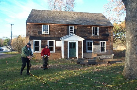
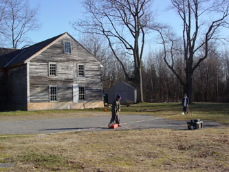
HAMPTON -- The present encountered the past recently when a hi-tech sub-surface survey was conducted on the grounds of the historic James House property in Hampton.
According to James House Association member Skip Webb, the results of the survey will reveal the former sites of objects located on the three-acre property, such as building foundations, pathways and farming areas. This information will assist the organization in planning future archaeological digs as well as implementing historical landscaping on the property.
The project began late last fall, when the James House Association tapped the expertise of Daniel Lynch of Soil Sight LLC, an archaeological geophysics company based in Providence, Rhode Island. The company specializes in providing high resolution, non-invasive geophysical surveys for the cultural resource management industry.
Over the course of approximately 3-1/2 weeks, Lynch conducted three separate surveys of the property using special computerized equipment to collect data. With the land surrounding the James House divided into a carefully measured and marked grid, Lynch began the survey.
The first "mapping" of the site was done with a magnetometer (EM-38), a task which used electromagnetic technology to gather and record information on the area below the surface. Resembling an object approximately the size of a yard-long 2x4 with an attached carrying strap and digital meter, the EM-38 was pulled along the ground parallel to the grid lines.
An unexpected computer glitch with the EM-38 cut this part of the survey short; however, the small setback actually worked in the favor of the James House project. Lynch had with him another piece of equipment called a resistance meter, a unit which gives better readings even though it takes a longer time to collect data.
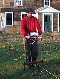
According to Lynch, the resistance meter "determines where there is a higher or lower resistance to electricity." Higher resistance readings indicate objects such as underground foundations are present; the lower readings will show, for example, where a pit may have been dug.
A two-handed approach is used to conduct readings with a resistance meter, with the data collector posted atop a two-posted mobile frame. As the unit is painstakingly moved one step at a time along the grid, low voltage pulses are sent out into the ground at each pause, during which a reading is taken. The resistance meter "autologs the whole thing," said Lynch, adding that eventually the gathered information "is printed out as a picture."
In order to fully utilize the resistance meter, "we had to clear most of the property of bramble, honeysuckle, bittersweet and saplings," explained Webb. This freed the way for Lynch to cover "the whole three acres" of the James House property.
"This is probably the largest resistance meter survey done in New England," according to Webb. And though it took a generous chunk of time to complete this phase of the survey, collecting the data was still a work in timely efficiency compared to "old-fashioned" methods.
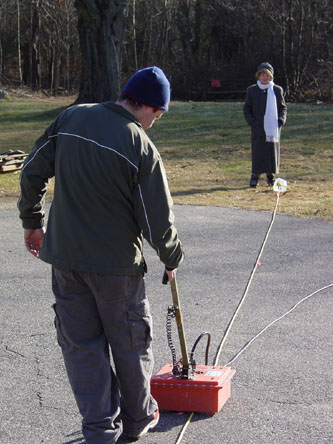
"Archaeologists used to write everything down only 15 years ago," said Lynch, who next used ground penetration radar equipment to conduct the project's final phase.
"It looks like a bucket with a handle," is how Webb described the box-like unit for this particular task. The equipment — which Lynch dragged atop the grid lines instead of beside them as before — sends electrical waves down into the ground; the waves then bounce back up to the meter and are recorded.
All of these readings have been compiled into a report which Lynch was scheduled to forward to the James House Association late this week for review. Once the findings have been considered ("We know from the survey there was an orchard and chicken coop," said Webb), steps will be taken to begin planning the archaeological digs and the historical landscape design project. The findings will likely be presented to the public in a related program, in order to provide more exposure for the James House and the ongoing restoration of the property.
James House Association members who were on-site to assist with preparations for the survey included Pat Weeks, Ann Kaiser, Bill Keating, Paul Corbett, Ben Moore, Richard Millette, Dave Colt, Lori Cotter, and Liz and Skip Webb. Soil Sight's Dan Lynch was recommended by Bruce Bevin, an archaeologist based in Virginia who in the past has led site digs at Strawbery Banke in Portsmouth.
According to Keating, the James House Association recently entered into contracts with several professionals to carry out the terms of the grant the Association has received from the New Hampshire Coastal Program. The grant was made to continue the preservation and restoration of the historic James House, and will help fund the professional services provided by Lynch as well as by archaeologist Sheila Charles; historic landscape designer Lucinda A. Brockway; and First Period Colonial Restoration's Bob Pothier.
The James House has been described as "a living museum of architectural and social history of early New England." A true "first period" colonial built for Benjamin James in 1723 near the salt meadows of Hampton, the James House "is regarded as perhaps the earliest surviving example of the two-room deep, center-chimney colonial in New Hampshire," according to the museum's Web site.
Added to the National Register of Historic Places in 2002, the James House "presents an important opportunity to preserve the architectural and historic value of a rare first period house." For more information about the James House, call Association President Bill Keating at (603) 926-2813 or visit www.jameshousemuseum.org.