Visitor's ABC's
Story and Photos by John Hirtle, Beach News Staff
Beach News, Thursday, September 8, 2005
[The following article is courtesy of Beach News]

Of all the state coastlines in the United States, none is shorter, more scenic or easier to drive along than New Hampshire’s Seacoast. It retains its beauty all through the year in its many shades of spring, summer, winter or fall, providing an easy trek that takes less than an hour to transverse ? provided you don’t pause to enjoy a view hidden by one of the many zigs and zags in the road.
The route begins in Salisbury Beach Massachusetts, where it is surrounded by beach cottages, restaurants, arcades and shops, which provide only fleeting glimpses of the ocean, the salt marshes and the drifting sand dunes. Salisbury Beach itself offers a long stretch of pristine surf scoured sand edged by amusements and restaurants. The Salisbury Beach State Reservation offers camping and a chance to get a closer look at the local scenery.
From here, you head north.
Once you pass the intersection of Route 1A and Route 286, you’re in Seabrook, where you can spy the lone dome of Seabrook Station on the opposite side of the harbor to the west. The lonely dunes and encroaching buildings harkens back to the way the landscape once was on the other side of the river in Hampton Beach.
You cross the Neil R. Underwood Bridge over the Hampton River to get into Hampton Beach. Immediately to the east is the Hampton Beach State Park RV Campground, the only campground located right on the New Hampshire Seacoast. It sits atop reclaimed land, which was once washed away as the river’s mouth slowly moved northward over the ages.
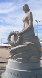
New Hampshire
Marine Memorial
Hampton Beach itself is the center of the Seacoast’s summer vacation activities. The harbor provides a homeport for boats that will take you out for whale watching, fishing and fireworks cruises. Here Ocean Boulevard runs north between long lines of hotels, restaurants, arcades and amusements and the broad sandy beach. At the center of the beach side lays a well equipped playground, which is fenced off to prevent any wayward child from running into traffic. Next to it is the bright blue Seashell Stage, which comes alive with music during the summer season. The local park offices, Hampton Area Chamber of Commerce’s visitor’s center and restrooms are located in this facility. A wheelchair ramp onto the beach is also located here.
Further on at the bend in the road is the statue of "The Lady" officially known as the New Hampshire Marine Memorial, which commemorates those New Hampshire sailors lost at sea during time of war.
By now, you will have seen parking meters lining the lots. The rate is 25¢ for ten minutes from May to October (2005). After October, the meters are removed, although the housing is often left in place, providing the illusion that you are still required to pay to park. The rocky point dividing Hampton Beach is called Great Boar’s Head.
North of it is a long concrete wall built atop a vanished line of sand dunes. Hidden behind the wall is a long grey strip of North Beach, which virtually vanishes at high tide. At any time of the year, when the waves are high, chances are that you can pull over and peer over the wall to spy some surfers catching some waves. From here north, most of the places you will come across are cottages and residences as restaurants become scarcer.
Continuing north, you pass through another group of cottages and enter the slim sliver of North Hampton’s coastline. A state beach lies below a high point called Little Boar’s Head. Here, weathered fishermen’s cottages huddle in one corner of the beach, in the shadow of mansions and expansive homes that are perched along the high ridge above. A long sidewalk starts next to the beach parking area, and leads north well into Rye, following the zig zags of this rocky scenic section of the Seacoast.

On the other side and to the west side of Little Boar’s Head sits Fuller Gardens, which is open from May to October. Once part of the private Fuller estate, these beautiful gardens are now open to the public. The mansions you pass as you go on into Rye are not, although you can guess at their opulence from the roadside as you drive by. The first public beach you come across in Rye is Jenness Beach, which has an unusually small lot to provide parking for such a long stretch of sand. The point marking the distant north end of the beach is Straw’s Point, where the first trans Atlantic cable to directly link Europe and the United States came ashore in 1874.
Further on is the picturesque port of Rye Harbor. Originally dug out of the salt marsh by Rye volunteers in 1792, it has been further expanded and enlarged over the years to its present size. A sizeable fleet of fishing and pleasure boats calls this little port home, and a number of charter boats can take you out to fish, watch for whales or even visit the Isles of Shoals which you can just see off the horizon along these portions of Route 1A during a clear sunny day. A small 'free’ pull off is located on the north side of the harbor just after the bridge here on Route 1A to permit visitors to enjoy the scenic vista. At the sharp zig right after the harbor is Ragged Neck State Park, which has a long sandy beach to the north, and views of the mouth of Rye Harbor to the south.
Along this section of roadway the water is hidden behind piles of cobblestones, which were piled up to prevent storm damage to the cottages sitting so close to the edge of the water. Once you clear this long wall, the road resumes its meandering zig zagging ways. Here though, there are more pull offs to allow drivers to take a moment to admire this rocky portion of the Seacoast.
More cottages appear on both sides of the road at Concord Point and the curiously named brook called "Stinky Creek". Concord Point has seen a few shipwrecks during the days of sail, and some planks can be seen at low tide in the sands of the beach. The old lifesaving station which once guarded this stretch of sand is long gone, replaced by a private beach club.
This 'hidden’ beach of Wallis Sands stretches from here all the way to the Wallis Sands State Beach, a compact public beach with a large parking lot. For those not interested in going to the beach, a pull off on the rocky cliffs that overlook the beach offers a spectacular view of the coastline to the south of you, and one of the better mainland views of the Isles of Shoals.
To the north, the rocky coastline returns, as do cobblestone barriers. Near Pulpit Rock, you will spy a tall concrete tower with slits near the top on the west side of the road. This was one of the many observation towers used to aim the guns of the coastal defense forts, which protected Portsmouth Harbor, had there ever been an attack.
As Route 1A turns inland, you will come across one of those forts, which is now Odiorne Point State Park, one of the largest public parks in the Seacoast region. The overgrown remains of Fort Dearborn, the last of the forts built on the Seacoast can be easily viewed at the south entrance, along with the Seacoast Science Center where you can learn more about the region’s long history and the environment. The north entrance offers a boat launch and access to an isolated beach along the shores of Little Harbor where the first settlement in New Hampshire, Pannaway Manor, once stood.
From here, Route 1A travels inland, towards the heart of historic Portsmouth and Route 1. For a final glimpse of the Seacoast though, one should take Route 1B, a rather elusive road that branches off Route 1A. To find it at this point, look for signs advertising Wentworth by the Sea, a recently restored Victorian era hotel which is the first thing you see as you drive into New Castle, the smallest town in the state of New Hampshire.
Route 1B takes you past Great Island Common, a large recreational area, and Fort Constitution at the U.S. Coast Guard Station where the first overt act of the American Revolution took place. Route 1B eventually leaves the island town and take you down a long causeway that follows the Piscataqua River. On the other side of the river is the imposing concrete "Castle" a former navy prison that now sits vacant on the grounds of the Portsmouth Naval Shipyard, the oldest shipyard in the country.
As with Route 1A, Route 1B winds up in the heart of historic Portsmouth, bringing your journey along the zig zags of the New Hampshire Seacoast to a close.